
Abstract
The sustainable urban planning of healthy and scientific smart cities relies on integrated strategies to balance technological advancement with the preservation of healthy environment. Furthermore, transi oriented development within the healthy smart city integrates resilient mobility one health and environmental data integration to design logistics zones and sustainable transportation systems that meet public health criteria and enhance productivity along strategic transports axes. Within the framework of sustainable planning for healthy and smart scientific cities the engineering of separation and integration is adopted. Spatial separation in the scientific spaces and logistics zone is applied to isolate operational risks, while connectivity ensure resilient urban environment via high speed data networks to sustain urban systems. This research plans the Ouzera City with a healthy urban fabric and smart interface featuring scientific space that meet the requirements of advanced scientific research rigorous one health approach and urban sustainability. The master plans for the healthy and smart scientific fabric of Ouzera City are based on the engineering of separation and integration. The separation aims to secure health facilities and the healthy urban space. while the integration ensures the exchange of research data for resilient and innovative environment. Within the framework transit oriented planning the logistic integration is planned via the smart interface within the logistics zone of the north south railway line along its segment connecting Chiffa and Berrouaghia.The engineering of separation and integration is applied to plan this logistics zone along the route integrating it with the north south motorway at its strategic axes and the following urban interchanges. El Hamdania and Tamesguida at Kilometer Point 66 , Médéa and Ouzera at Kilometer point 78. Ouzera at Kilometer Point 81, Benchicao and El Omaria at Kilomter Point 87 Berrouaghia between Kilometer Point 95 and 97. Additionally, foodstuff freight stations are separated from heavy goods and building materials to prevent environmental and vital urban space are achieved in passenger stations by adopting ecological planning, efficient and resilient design within healthy and vital environment.
Keywords
artificial intelligence recruitment personnel selection algorithmic hiring human oversight critical literature review
1.Introduction
Balancing the strategies of separation and integration in the sustainable planning of scientific and healthy cities presents both engineering and environmental challenges ; sensitive facilities require strict isolation to ensure security and safety and challenges particularly evident in the planning of scientific centers of research , park of science and technology conversely a smart approach to scientific cities necessitates continuous integration and interaction to foster innovation and leverage diverse ideas within a unified scientific framework.
How can balanced strategies planning be achieved for the centers of research associated with the University Pole of Ouzera within realm of science and technology?
And how are environmentally sensitive research zones delineated and connected via integrated smart research networks the support rapid data exchange to foster research , innovation and smart development.?
While the strategy of separation and connecting railway networks aims to enhance efficiency and integrate operational risks specifically by separating stations of passengers and freight stations to ensure a healthy environment their digital and smart technical integration within a smart urban environment remains essential for achieving efficiency and urban resilience.
How can logistic hub be planned within the railway line passing through the wilaya of Médéa while protecting the urban environment and enhancing the operational efficiency in the station of passengers at the interchange hub of Ouzera ?
And how can the integration with the road network and infrastructure be achieved to ensure the resilience of urban areas ?
2. Strategies of scientific and healthy urban planning.
The urban strategies for sustainable planning scientifically grounded and health oriented urban planning require integrate models based on urban systems and its built environment incorporating advanced interdisciplinary intersections.
These strategies rely on advanced bibliographical analysis that integrates analytical frameworks for scientific and health focused planning across the following axes:
-
One health : Recent studies have moved beyond the traditional link between the environment and health in favor of one health approach which requires planners to incorporate green spaces as environmental filters and areas that support ecological balance.
-
Smart planning and urban resilience :Recent studies have focused on extending the concept of urban intelligence to encompass resilience utilizing big data to predict urban health risks and integrates vital services efficiently and effectively.
-
Structural and ecological planning: The studies focus on biomimetic inspired for resilient infrastructure to ensure urban system stability and employ spatial distribution that guarantee efficient congestion free access to services alongside the adoption of biophilic designs to create ecological and healthy cities.
3. Urban observatory models for healthy and smart planning.
The urban observatories models of Ouzera city focus on selecting issues of urban significance and addressing the quotidian life of citizens.
Based on these observatories the urban environment,t is guided and developed in harmony with the healthy environment of smart scientific space.
To achieve a scientific , healthy and smart urban environment in Ouzera city , the engineering of separation and integration is applied across key axes based on two urban observatories that integrates urban activities with the healthy space , the models of observatories are integrated to be formulated within the developmental master plan of Ouzera city
3.1. Urban observatories of interior finishes
The sector of building activities and interior finishes in urban areas suffers from a lack of integration with healthy environment standards particularly regarding the activities of material production in activity zone as well as waste generation in interior fit out works
Furthermore the master plans of health are absent leavening gaps in general master plan that fail to account for the impacts of these activities on urban spaces
To forsee a healthy environment for Ouzera city the urban observatoery of interior finishes is modeled using a field technical approach that combines material usage and execution with practical readings focusing on interior finishes as a models for the most skilled in the traditional urban fabric of Ouzera
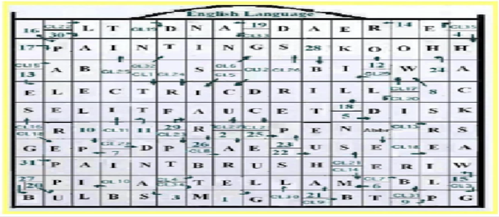
The urban monitoring model represent field approach to interior finishes using material and tools
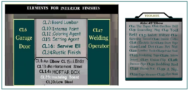
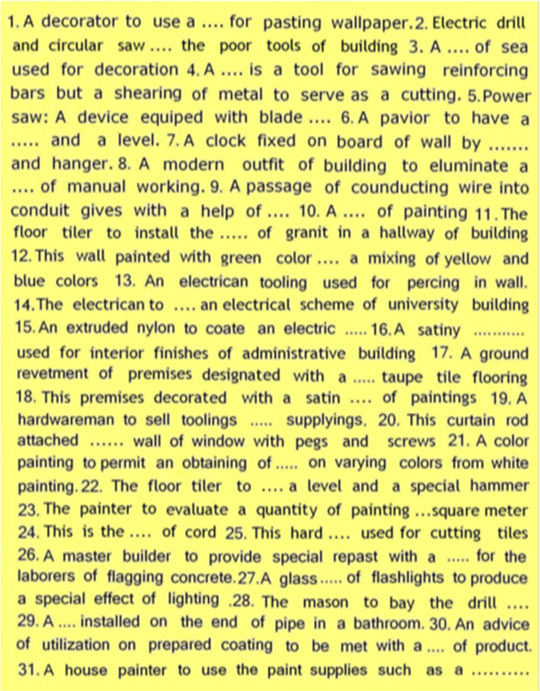
Practical readings provide an overview of the reality of interior renovation in Ouzera with an emphasis on interior finishes in shops and buildings
3.2. Observatory of rapid food services
Rapid food services in Ouzera city are witnessing along main street and with the completion of scientific and urban poles these services could expand into new spaces potentially giving rise to unhealthy consumption patterns. .
The model of rapid food observatory represent a model for the customer services experience in Ouzera
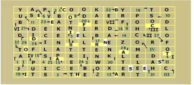
The reading analyze rapid food services from a practical perspective within a traditionnel urban environment

3.3. Separation and integration engineering for smart and healthy city
Planning healthy urban environment in Ouzera as smart city requires a precise identifications of existing infrastructure to eliminate urban imbalances and environmental healthrisks , it also entails establishing new infrastructure integrated with exesting structures to ensure the samrt operation of city in healthy environment.
Two vital domains representing practical life in urban space are addressed where en,gineering of separation and integration ensures sustainable planning in the fields of renovation and catering services within the smart health environment adaptation. Through the urban separation strategy scientific spaces and spaces of health are preserved via green area and smart facilities where individual fit out works are prohibited
Additionaly the industry of buiding materials separated outside the urban fabric into an isolated zone in the northern territory of Ouzera. The area of building materials trading are separated by directing activities outside the urban area near the national raod in a suitable location west of Ouzera city while a commercial stores is integrated at the western entrance of Ouzera city along the vital road for the sale of sanitary ceramics as part of effective integration within resilient and healthy urban environment.
The craft professions are integrated with environmental statdards through the establishment of a training center of building and landscaping .
The rapid food and restaurant services are separated from area of craft activities and integrated along main streets and the vital stret to facilitates supply chains and ensures food safety. The catering services are integrated with various facilities in urban fabric and smart urban spaces through rapid and healthy delivery services.
4. Master plan of smart urban environment.
The master urban planning plans are based on the built up sector within the context of conventional urban architecture and the sectors designated for development within a smart scientific and health oriented space aligned with a future oriented sustainability strategy as well as non buildable areas integrated into the framework of a healthy ecofriendly city and a bio diverse region.
4.1. General urban master plan
The master plan for the development of Ouzera City is based on published studies addressing planning and design through biomimetics , the one health approach , healthy environment , city landmarks and urban resilience , biophilic design , urban metabolism ,vital and commercial interface , zone of activities , center of commerce, scientific pole , hub of health and interchange hub.
The master plan incorporates urban resilience by allocating sufficient space for parking on the eastern , western and northern sides.
It also prioritizes the ecological character of city by providing ample gardens and green spaces while public places foster integration among the urban areas supporting the vision of scientific and health oriented city.
The general master plan of Ouzera City comprises two main sectors :
-
The built up sector : wich includes land occupied by community buildings ,green spaces , basic services facilities and public facilities.
-
The programmed urban development sector comprising lands designated for urban development in the medium term to 2030 extending to 2050 horizon.
The urban vision for the smart interface of Ouzera City is based on integrating technology with advanced healthcare and scientific research to create a scientific and healthy urban environment
The scientific and health hub services as the cornerstone of this plan which stems from the regional plan of territory development strategy for 2035 horizon.
This strategy designates Ouzera as an ecological zone primarily dedicated to health positioning the pole of health of Ouzera city serving as beating heart.
The hub is designed as accordance with the standards of smart scientific city.
In this smart scientific and healthy city the activity zone and vital face of commercial activities serve as the economic engine mean while the center of commerce , public place and green areras ensure integrated urban services and the technological infrastructure provides smart network and digitized services all managed by the city administration , which oversees the smart city hubs including the interchange hub that guarantees resilient and sustainable transportation services
The general master plan of the scientific smart and health oriented city of Ouzera is based on a sustainable urban vision accommodating a population density exceeding 50 000 inhabitants , distributed across a central pole and two main hubs located in northern and eastern of Ouzera city. In the north ,extensive land has been located for urban development ,specifically for the national housing program of AADL: meanwhile , in the east , the existing cecondary center of Ouzera is being expanded into a new hub ,anchored by the architectural interface of the AADL housing developments
The central pole integrates all vital and administrative facility including the university seat , the central zone of activities and commercial zone and the urban core within an intelligent interface and exchange hub,it features a density appropriate for a healthy environment and urban resilience for the urban core of Ouzera city.
The remaining population is distributed with 20 000 inhabitants in each of following the northern pole which features infrastructure of logistic zone of food and a center of convalescence integrated with a specialized university hospital.
The eastern pole which houses a specialized university campus in one health , a research center dedicated to one health a specialized zone of activities and a population density of 20 000 residents.
These urban poles are harmoniously integrated through a hybrid matrix from urban perspective via public facilities and public spaces , squares and commercial zones , and ecologically via forest expanses , green spaces , urban parks.
This integration combined with ecological zoning ensures a healthy and resilient scientific urban environment that optimizes medical and therapeutic services for an appropriate population density for health services.
4.2.Master plan of healthy urban environment
The health and environmental master plan for the city of Ouzera adopts the one health approach which focuses on human health , animal health , and the safety of ecosystems across the territory of Ouzera.
The master plan for the scientific and healthy smart city of Ouzera is built upon an integrated model for human health within both the urban environment and across the region , alongside animal health and ecosystem safety thought the territory.
In the domain of human health , this model integrates specialized medical healthcare , scientific research , and sustainable infrastructures , the plan features an integrated medical health resort complex , spearheaded by university hospital specialized in laparoscopic surgery , accompanied by functional housing for specialized physicians to ensure continuous readiness , alongside the faculty of medical sciences bridging clinical practices with academic research .
Furthermore the center of analysis and medical diagnostic reinforces the humanitarian and social dimensions of healthcare.
The plan also includes a lodging , center for companions of patients to provide a supportive healing environment in addition to a network of multiservice clinics covering urban areas according to precise standards integrating two clinics in each new urban pole to bring the total of five multi services clinics; alongside clinics in rural areas
All healthcare services serves the population density exceeding 50 000 inhabitants and ensure the quality of urban and environmental life across the region.
The plan incorporates green spaces including parks , public squares and the municipal park responsible for the modern and management of urban areas and household waste.
The civil protection ensures rapid intervention and immediate response to various emergencies within an integrated resilient healthy system .
Additionally , the exchange hub guarantees resilient mobility and continuous access to advanced health services in smart interface of healthy city.
In the domain of animal and health and ecosystem safety the master plan model incorporates the center of research on one health , the center for animal health and productivity , a specialized veterinary center integrated with the logistic zone of animal health , laboratories of analysis and research on food and produces integrated with the logistic zone of food.
5. Planning and design of advanced center on research and medical diagnostic
Planning the integrated infrastructure of health represents a structural response to achieving prompt and effective medical services.
The infrastructure project of the advanced medical analysis and diagnostic center within the ecological zone in the east area of Ouzera embodies an integrated space of health alongside the specialized university hospital in minimally invasive surgery and the hospital of oncology. It serves as an advanced facility guaranteeing advanced medical diagnostic services integrating the hospital institutions for the central region in Algeria.
Strategically positioned alongside the wilaya road n 51 within the eastern sector of Ouzera Close to the North South Motorway .
The sophisticated center of analysis and medical diagnostic forms a strategic extension within the overall structure of the health pole. It integrates resilience with the exchange hub at the smart interface ensuring rapid traffic and logistical fluidity ,as well as robust connectivity with scientific and hospital facilities and the network of transportation.
This makes it a complementary facility to the smart health system , achieving optimal operational efficiency for the pole of health and ensuring high level training advanced medical diagnosis thereby fulfilling the specialized pedagogical efficiency in the faculty of medical sciences particularly in the advanced laboratory of medicine and diagnostic pathology.
5.1. Planning via separation and smart connection engineering
The architecture of the medical research and diagnostic center relies on healthy separation and smart connection engineering which ensures the complete isolation of vital pathways to prevent any cross contamination between research , diagnostic and administration sites.
A closed bio environment is implemented to prevent the transport of contaminants between floors and wings.
The center consists of four distinct wings housing department designed to accurately cover all pathologies in accordance with approved standards .
-
Department of medical analysis and genomic research.
-
Department of clinical analysis and data management .
-
Department of medical education and laparoscopic surgery simulation.
-
Department of medical imagery and advanced diagnostic
Each department comprises four floors with the top floor dedicated to administration and scientific research.
The medical education and laparoscopic surgery simulation wing houses a lecture hall and the central administration of the medical center .
Whereas the clinical analysis and data management wing accommodates the big medical data processing server room.
The laboratories are situated on the ground floor with research platforms integrated into each wing.
The advanced medical analysis and diagnostic center integrates seamlessly via a central digital system with the specialized pole of health .
The big medical data is securely exchanged with operating rooms to maximize operational speed while maintaining stringent environmental and standards and health safety.
Furthermore , the road and guided transport network through the exchange hub guarantees effective integration for the resilient accessibility of patients and medical staff.
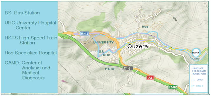
The medical and urban services are integrated through transport lines provided by small shuttle vehicles that operate along the main roads within the urban fabric , starting from the station adjacent to the center of trading in the centre of Ouzera city with a waiting time of no more that five minutes per vehicles in circular loop system.
The route passes through the station located near the train station at the interface of exchange hub which operates on the same mechanism and continues along a path passing near the hospital of oncology in the urban pole as well as the advanced center on analysis and medical diagnostic in the east o of Ouzera city , before returning in a circular loop system to the station in the centre of Ouzera city
5.2. Biomimetic design of the advanced center of analysis and medical diagnostic
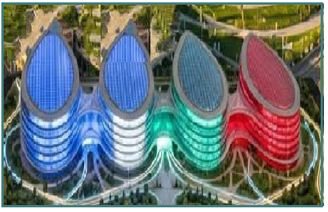
The wings of advanced center feature on symmetric aerial design inspired from the shape of water droplets ,this dynamically resilient and flexible design visually and functionally expresses , the precision and purely required in the medical and therapeutic fields.
Moreover , this geometric configuration provides fluidity that prevents wind stagnation and permits natural lighting from all angles within an ecological space entirely free of urban heat islands
6. Planning and design the zone of research activities
The strategic planning and intelligent design of the zone of research activities represent an integrated model for the empowerment and innovative university within the fourth generation of scientific and technological spaces.
The planning includes the establishment of the complex of scientific and technological laboratories for an integrated set of specialized and vital disciplines focusing on energy ; materials ; mechanical engineering , and process engineering .
These laboratories are integrated with the center of research in optics and precision engineering within an intelligent research space guided by the intelligent scientific framework of b healthy and smart scientific city of Ouzera.
The space of scientific and applied research is established in an ecological area extending within the urban fabric isolated from extensive agricultural areas east of Ouzera city featuring a smart platform along the wilaya road n 51.it incorporates into the scientific structures of the smart scientific city .
The center of research in soil , materials , structures , and urban metabolism carefully positioned within a dedicated zone to ensure healthy separation and scientific integration .
The integrated space provides a resilient and safe working environment without interference from sensitive laboratory processes .
The scientific and research space integrates with the central space of fourth generation university, which include the faculty of sciences and the faculty of technology.
The system of research and development crystalizes within a resilient , smart environment that supports health and scientific ecosystem forming a space and cooperation between university research centers and the economic environment.
6.1. Planning by engineering of separation and integration for the scientific and technology
The planning embodies the engineering of separation and integration to establish scientific and health spaces in the healthy and scientific smart city of Ouzera under a sustainable model of smart urban planning.
The urban fabric and the pole of sciences and health are meticulously organized to achieve maximum operational efficiency and biosafety.
The scientific and technical zone which houses the laboratories of science and technology forms the basis of research services within the smart scientific space of Ouzera.
6.1.1.Spatial Planning
The laboratories of science and technology is located in the area of the medical analysis and diagnosis center.
The engineering of separation is adopted to construct a specially engineered road designed for traffic flow , separating vehicular traffic from vital and health services pathway , extending from wilaya road n 51 , this road is dedicated to scientific research activities flanked by parking and green spaces .
This security based separation ensures urban resilience and achieves high levels of operational safety between human mobility , logistical axes and vital area and area of research and health .
The urban system of continuous transport provide linkage axes that efficiently integrate research and medical infrastructures.
6.1.2.Structuring the complex of scientific and technological laboratories.
The laboratories of science and technology stands as an integrated scientific and technological structure comprising advanced laboratories of research structured a follows:
-
Energy laboratories : Specialized in research of renewable energy , energy efficiency in healthcare facilities and the development of sustainable system in smart cities.
-
Materials laboratories : Focused on advanced materials , specializing in biomaterials and nanomaterials.
-
Laboratories of mechanical engineering : dedicated to the design of precision equipment with a focus on thermodynamics and renewable energy .
-
Laboratories of processes engineering: Studying environmental processes and materials related to the pharmaceutical and textile sectors.
6.1.3.Center of research in optics and engineering of precision
The research center in optics and engineering of precision serves as the primary engine and innovative core within the complex of science and technology .It specializes in developing optical system of precision and sensitive measuring devices related to healthcare and a advanced engineering and its applications in medicine.
This center integrates with the specialized university hospital for laparoscopic surgery , developing optical tools and modern technologies and aligns its research with the manufacturing of textiles to promote innovation in smart production processes Furthermore , this center leads cross disciplinary research with the technical laboratories of research .
6.1.4.Scientific and technical integration with academic spaces and smart healthcare facilities
The scientific and technical zone of research integrates with the academic and healthcare facilities of the smart city. This strategic integration is evident with the faculty of technology and faculty of sciences in advancing research and contributing to innovation .
The medical integration is also achieved with the university hospital specialized in minimally invasive surgery and the hospital of oncology ensuring total operational efficiency and innovation in optical engineering of precision in advanced surgery.
The laboratories of research integrate with the specialized manufacturing of textile designed for garment design and the production of smart medical apparel bypassing traditional weaving and dyeing fabric industries.
The units in manufacturing rely on advanced technology of textiles aligned with the environmental standards of smart and healthy city.
6.2. Biomemitic design of the scientific and technical zone
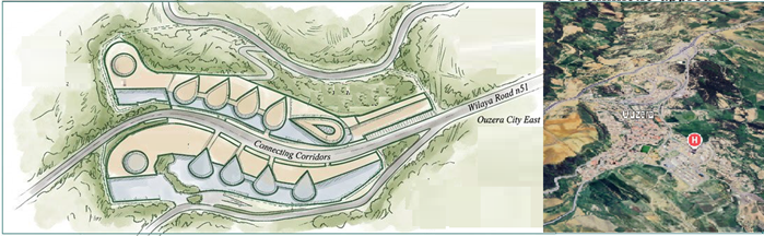
The design of scientific and technical laboratories of research incorporates a biomimetic approach centered on a water droplet motif .The laboratories dedicated to energy , materials , mechanical engineering and process engineering are structured in the form of cluster of water droplets to ensure spatial separation while structured integration is achieved via corridor connecting the ground floors .
With each wing comprising a ground floors and two upper levels , in contrast the center of research in optics and engineering of precision takes the shape of a lager water droplet of the height of 4 floors crowded with a smaller water droplet shaped dome and is positioned as a landmark of smart platform in the frontage of wilaya road n51.Meanwhile , the remaining laboratories of sciences and technologies occupy the lateral space with a façade harmonized and consistent with the center of medical research and diagnosis.
6.3. Reslilent planning and biophilic design for the center of research in building and urban metabolism
The spatial configuration of the center of research in buildings and urban metabolism exemplifies a paradigm of sustainable spatial organization , seamlessly synthesizing advanced architectural adaptability with deep ecological integration , situated within the urban fabric of Ouzera ; the center establishes a vital nexus integrating hybrid network while fostering a strong synergy between construction engineering and materials urban metabolism .
6.3.1.Spatial organization and hybrid integration
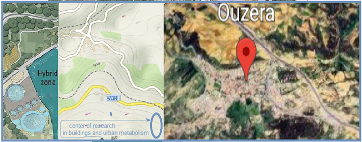
The center adopts a spatial logic predicated on separation and integration .it is separated from zone od research and medical analysis to preserve operational focus , it is strategically anchored within the extended urban fabric of Ouzera .It forms a hybrid zone alongside the training center of buildings and landscaping while maintaining direct academic and technical synergy with the civil engineering department at the central pole of university .
The primary access routes are engineered to accommodate light freight vehicles transporting materials of construction to main vital networks .the design preempts urban traffic disruption and guarantees seamless supply chains logistics
6.3.2.Architectural typology of the center of research in buildings
The main building rising two floors , in the areal shape of water droplet sypolysing systemic fluidity and resource flow. The laboratories and spaces of materials are designed in harmony structures with adjacent laboratories of soil and materials designed as staggered water droplet in areal view.
These spaces are meticulously allocated for raw material storage and educational laboratories while the main building is dedicated entirely to applied research and research development
6.3.3.Architectural typology of the center of urban metabolism
Spanning a ground floor plus two upper levels , the urban metabolism research center mirrors the geometry of droplet and is deeply rooted in biophilic design , the center is encircled by cascading waterfalls and motifs of water surface in the shape of droplets , creating an immense , sensory connection with nature.
The center is enveloped by a dense perimeter forest comprising gum trees , cypress , pine trees.
The course of water are bordered with oleander and wild olive trees significantly enriching local flora.
Furthermore , dedicated shrub land green area is integrated to cultivating a resilient urban ecological space.
6.3.4.research integration in the center of buildings and urban metabolism
The colocation of research in buildings and urban metabolism research within an integrated space transcends mere spatial proximity; it constitutes a conceptual synthesis of circular city model by converging the civil engineering department , vocational training , applied laboratories and materials metabolism.
The center operates as a perimeter incubator for green buildings technologies.
7. Spatial integration of TOD and engineering of separation and integration for sustainable logistics hub
The North south railway project specifically its section connecting Chiffa and Berrouaghia serves as a vital arterial route for passenger and freight transportation functioning as a primary driver of national economic development.
Transit oriented development with planning aims to establish a logistics hub system anchored by railway stations integrated with north south motorway interchanges.
This framework ensures rapid secure and sustainable supply chains alongside vital urban logistics through specialized stations along of the interchange of motorway in the section of Chiffa Berrouaghia.
These penetrating center foster a healthy environment reduce multimodal transportation costs and resilience respond to the socioeconomic needs of regional populations.
The engineering of separation and integration is applied to regulate material and commodity flows mitigating pollution and congestion . The terminal network is structured as follows.
-
Intermodal station near the motorway interchange of El Hamdania.
-
High sped passenger rail stations south Ouzera and the west of Berrouaghia.
-
Intermodal station of passenger and freight in Benchicao.
-
Freight terminals north Ouzera and in the west of Berrouaghia
The segment of penetrating center adopts semi high speed train from Chiffa and Boughezoul which stop at intermediate stations to serve passenger and regulate the high sped trains during winter conditions
7.1. Engineering of logistical integration of intermediate railway station to motorway interchange El Hamdania.
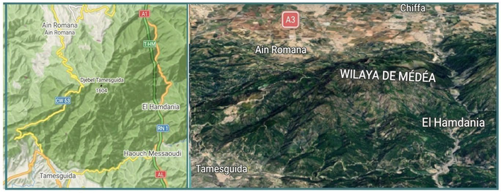
The integrated intermediate station combined with the motorway interchange at Kilometer Point 66 forms a pivotal engineering and logistical link within the north south railway project.
The core functions of this station at the motorway interchange heading towards ElHamdania and to Tamesguida are embodied in providing operational data for automated guidance and control systems. Securing the tunnel sector and coordinating resilient transit from and to Chiffa via Mouzaia and Ain Romana.
Furthermore , this station monitors and secures the highway overpass transit between Kilometer Point 67 and 68. Challenging terrain east of motorway line is traversed from and to Chiffa the intermediate station at an altitude of 430 meters with gradient reaching 2.05 per thousand .
Transit is achieved through equipped tunnels these structures are supported ventilated side service paths emergency exits and operational control rooms activated at the intermediate station.
The mountainous road network along this line is developed as key access routes to tunnel prtals and emergency exits.
Technical integration is established between the meteorological station near the intermediate station at El Hamdania interchange the metrological tower at the western entrance of Ouzera City which the train reaches passenger stations at Kilometer Point 81 over distance of 17 Km with gradient not exceeding 3 per thousand .
Crossing east of motorway toward the freight station north Ouzera is accomplished via bridges and open alignments
This intermediate station operates as an advanced systems for semi high speed passenger trains. alongside a dedicated sub station designed for heavy freight trains to prevent environmental impact on the nearby riverbed utilizing resilient and efficient logistical layout
7.2. Freight rail station as a core component of the smart urban interface of Ouzera
The exchange hub within the smart interface of Ouzera represents a strategic smart model of ecological infrastructure within this hub rail transportation is engineered within an economic framework by planning the pivotal logistics zone of foods in the east of Médéa located not far from the motorway interchange at Kilometer Point 78
This infrastructure integrates transit oriented development and the engineering of separation and integration within the strategic smart exchange hub to ensure the highest levels of operational efficiency and urban resilience for both passenger and freight stations in a healthy environment that achieves regional balance according to the environment of one health.
The planning constitutes sustainable development rested in environmental health ,multimodal integration and functional density oriented toward the smart logistics zone.
The freight station north Ouzera manages the economic arteries for goods and supplies at low costs due to its proximating to the traffic interchange and bypass of Médéa City , which reduces cross regional truck transportation time.
The station site also includes extensive spaces for unloading and storage within a secure ecological zone.
Grain , Rice and Corn storage silos are designed and constructed across areas that fulfill the principle of spatial separation and integration with the road network via the motorway interchanges at Point Kilometer 78.
The design is logistically vital , and the storage silos represent a distinctive landmark on the interface of Motorway maintaining crops under technical conditions that ensure quality preservation by securing them in healthy zones.
The freight station in the northern of Ouzera is designed in an ecological zone following the approach of environmental health and sustainable transportation situated at an altitude of 800 meters . it is located one kilometer away from the tunnel passing beneath the motorway at Kilometer Point 79 and maintaining the same distance from the northern urban area of Ouzera as illustrated in the figure
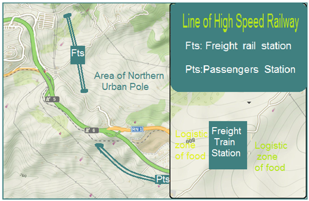
The railway line passes through a one kilometer long in tunneling beneath the motorway at a depth of 50 meters with a gradient not exceeding 30 per thousand reaching the passenger station south of Ouzera city at an altitude of 850 meters
7.3. Passenger railway station within the intermodal hub of Ouzera
This passenger railway station occupies a a prominent site at the interface of Ouzera city
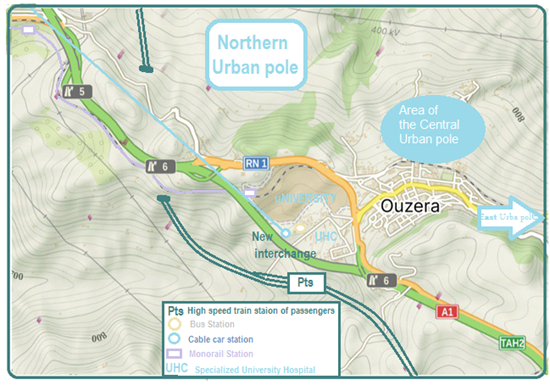
The intermodal hub integrates several key transit modes ;a bus station , a cable car station providing access to headquarters of Médéa via administrative pole and the main bus station in the north of Médéa.
A monorail line connecting intermodal hub of Ouzera to headquarters of Médéa ,this monorail route passes through the zone of Draa El Smazr along the historic railway alignement , effectively restructuring the urban economy of Médéa while linking outlying regions through a cable car extension stretching toward Ain Jerda and Tamasguda.
The landscape architecture of this station drow iconic landmark for a healthy pole with environmental health and specialized university hospital.
This railway station incorporates commercial activities of Informatics and electronics in healthy area integrated landscape spaces.
This planning is guided by the one health framework and healthy environmental approach anchoring in facilities within smart and scientifically driven in ecological zone.
7.4. Smart operations of the freight and passenger stations in the smart interface of Ouzera
The smart operation of the freight and passenger stations in Ouzera relies an integration with a meteorological tower designed as an urban landmark at the western entrance of Ouzera city which gathers meteorological data from its subordinate stations.
The transportation system operates on the principle of urban metabolism focusing sustainability on energy and data during snowfall and harsh winter conditions and linked to automated control algorithms that dynamically direct train and freignt between the northern and southern stations to prevent thermal congestion. The network within the meterological tower issues signals to power ventilation systems and railway heating mechanisms to prevent snow accumulation and automatically reduce speeds at tunnel entrances.
Furthermore , the data ensures the intelligent deployement of snowplows from both stations during severe conditions , guaranting safe and conditions operations . The smart system across both stations and the tunnel ensures the rapid and efficient mobility of civil protection units during emergency from their centers via the motorway providing safety along the route.
7.5. Intermodal station of passenger and freight in urban area of Benchicao
The Benchicao intermodal station of passenger and freight serves as an intermediates logistics platform within a transport oriented development strategy aimed at fostering sustainable regional growth .
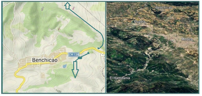
This station is designed on integration of motorway interchange et Point kilometer 87 featuring a secure passenger platform with direct access via wilaya road 138.while freight logistics routes are routed along dedicated roadways on the opposite side completely isolated from passenger entrance.
The freight tstation is specifically dedicated to agricultural produce equipped with cold storage warehouses and agricultural consolidation site designated for fresh goods .
Situated at an altiturde of approximately 1100 meters the station runs parallel to the wilaya road 138 near the urban boundry , maintaining an optimal setback distance within a site sufficiently expansive to accommodate all station.
The distance between the Benchicao station and the station of Ouzera is approximately 7.5 kilomers with an elevation difference of 220 meters .
The rail section connecting Ouzera and Benchicao stations presents unique engineering challenges regarding gradient angles along route overlapping the old railway paths.
This alternative alignment ensures a maximum gradient not exceeding 3 per thousand to guarantee optimal braking and tractive efficiency , complemented by curves with safe radii for high speed train this provides a secure railway compared to the legacy path which suffered from sever gradients tight curves and frequent disruptions during frost and snow conditions.
Based on the topographical analysis , the route includes two short tunnels designed to avoid technical complications as high voltage power lines are crossed via technical tunnel , and an equipped tunnel crosses under the wilaya road 138 to reach the Benchicao intermediate station.
The new alignment utilizes bridges of concrete structures to bypass areas vulnerable to severe crosswinds and is
Equipped with healthy and deicing systems to present the operational failures characteristic of the old route ,while intentionally avoiding long , deep mountain tunnels .
These bridges offer panoramic sights and incorporate landscape engineering structures visible along the motorway bridges.
Furthermore the distance between the Benchicao station and the exchange hub of Berrouaghia is approximately 11 kilometers featuring 220 meters elevation difference in this distance gradient of 20 per thousand and turning radii compatible with maximum operational speeds.
7.6. Multimodal interchange hub of Berrouaghia
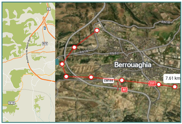
The Berrouaghia multimodal interchange hub is strategically situated at a vital intersection connecting national roadway networks with the north south railway line.
Along the Chiffa Boughezoul railway line the route intersects with national road 62 which connects to national road 18 near the interchange of Berrouaghia with the logistics zone between Kilometer points 95 anf 97 of motorway.
The freight and passenger station is strategically situated in the resilient site within an optimal spatial framework enabling cargo transit without traffic congestion .
The passenger transit routes are completely separated from freight station area to prevents noise and pollution along the access road leading the center of Berrouaghia .Furthermore , the integration of passenger station with the land transport station and the urban fabric is achieved through a continuous cable car ,line connecting the bus station , the high speed train station and the main roads on the western side of Berrouaghia city
The separation in railway station is enforced within this interchange hub by isolating the passenger transit from the freight area dedicated to buildings materials and heavy goods to ensure safety and efficient mobility and integrated with digitalization for logistics operations.
8.Structural efficiency and environmental assessment of penetrating center
The engineering of separation and integration represents a strategic tool for mapping the railway line and guiding sustainable environmental planning .
Structural efficiency is embodied in the selection of the penetrating center for the north south railway line in its section linking Chiffa and Berroughia.
This is achieved through structural integration with strategic axes of motorway alongside logistical hubs and essential stations of passenger that respond to depographic concentration and high population density within critical elevation ranges between 800 and 950 meters passing through the region of Ouzera and Médéa and reaching the strategic highlighlands between 950 and 1200 meters via the area of Benchicao with the concentration of density and the presence of strategic motoway interchanges along the penetrating center.
The proposal for the the railway line passing south of Médéa at lower elevation near the valley around 690 meters proves unfeasible.
The main station on this bypass line is located within the zone of urban metabolism outputs , fragile urban expansion areas and close proximity to the industrial outputs of the Saidal Group and the landfill in the Draa Essmar zone.
8.1. Structural efficiency of the penetrating center
The structural efficiency of railway penetrating center demonstrated by its capacity of effectively serve existing and future urban areas compared to the bypass line where intermediate stations are altered .
Additionally locating the main station in an unstructured semi urban area limits smooth passenger transit and imposes a financial burden associated with maintaining the extended distance toward Boumedfaa station.
In contrast the penetrating center passes through Ouzera region within an urbanely structured and harmoniously integrated space ensuring smooth passenger access .
The optimal distance ensures long term reductions in operating costs and higher returns on investment within strategic axes and logistical areas.
8.2. Assessment of environmental impact
The railway line of penetrating center carries an environmental footprint that is less damaging to ecosystems compared to the bypass line extending to Boumedfaa which traverses areas of high environmental sensibility characterized by dense industrial smog extending into the valleys where the main station was proposed compared to the penetrating center.
The bypass line consumes additional land over several extra limes within fertile soils and utilized pastoral areas , causing spatial fragmentation and division of environmental and agricultural lands .Meanwhile , the penetrating center preserves ecological balance by bypassing the Tamazguida massif via bridges and tunnels , providing and integrated logistical zones aligned with strategic intercheanges of motorway far from urban metabolism outputs and industrial discharge outlets.
8.3. Description of the environmental health of penetrating center
The environmental health of the penetrating center is characterized by pristure air and distance from inductrial and organic pollution hotspots, the line passes through ecological areas where the pole of health in Ouzera serves as a center of hospital and therapeutic services within a healthy environment.
This layout enables seamless integration between railway transportation and the transports by roads at strategic locations featuring an advanced healthcare facilities with interchange hub situated within 800 and 1200 altitude rang amidst concentrated population density extending toward eastern and western of Médéa.
Conversely the proposed bypass route south of Médéa city in semi urban area features a degraded environmental health resulting from proximity to urban metabolism and industrial discharge outputs in atmosphere ladder with airborne pollutants particularly during periods of atmospheric stagnation and dense valley fog.
The hybrid penetrating line by bypassing the Tamezguida mountain massif through short bridges and tunnels remains highly efficient and effective in providing integrated access to advanced health services along environmentally sound and healthy route far from industrial and organic pollution zones in an ecological areas at a level higher than, the urban metabolism outputs.
8.4. The penetrating center and landscape architecture
The penetrating center line originates in the plain region , skirts the tamezguida mountain massif ,and passes through the station of Ain Romana .
The railway line is characterized by natural landscapes to the west , heads in the face of Tamezguida amidst urban natural scenery , and reaches the station of Houch El Messaoudi via panoramic sights framed by high bridges .
It extends to cross the motorway toward the mountains of El Hamdania with bridges and panoramic views and reaching the ecological area of Ouzera which is distinguished by its urban landscapes architecture .
This routes offers passengers a visual journey through green landscape and snowy sights.
It integrates seamlessly with natural gradients and demonstrates a significant superiority over the proposed bypass line which traverses environmentally fragile aeras and predominately industrial zones .Such industrial dominance strips the alternative of touristic dimension that characterizes the penetrating center as it passes through Tamezguida and Benchicao along a panoramic senery , ultimately reaching the city of Berrouaghia at a station distinguished by its vews of motorway structures within a natural environment harmonized with urban area
9.Morphological challenges and hybrid planning of penetrating center via separation and integration engineering and landscaped design
This paragraph addresses the morphological challenges of ploting bthe hybrid planning of penetrating center tocross the Tamezguida mountain massif by looping westward to reach the Ain Romana railway station starting from the station of Houch El Messaoudi at an altitude of 430 meters and reaching Tamezguida at an altitude of 580 meters with a gradients angle not exceeding 3 per thousand.
This section faces morphological and climatic challenges represented by steep slopes in the fragile terrain of Médéa region .The presence of monkeys as well as conditions related to snowfall and fog in the highlands.
To overcome these challenges safely , the optimal elevation is determined at levels that ensure clearance from snow and fog peaks and avoidance of the monkey population.
The planning relies on separation and integration engineering combined with landscaped design adopting an open hybrid line with a limited number of intermittent tunnels whose total length does not exceed foor kilometres , integrates with giant bridges.
The structures ensures the crossing of low terrains and deep valleys with complete fluidity and high safety in a healthy ecological environment.
The railway track is separated from the monkey habitat by looping around the Tamezguida mountain massinf at open levels not exceedings 600 metres,with route protection via specialized systems at tunnel entrances.
The high bridges alow forest animals to pass without fragmenting their natural habitats.
The route shown on the map represents a model for the hybrid line conneting the station of Houch ELMessaoudi station to Ain Romana station by looping around the Tamezguida mountain massif featuring penetrations through short separated tnnels integrated to bridges designed with landscaped engineering in an ecological area away from the rainforest habitat of monkey and geological complexities deep within the mountain range .offering panoramic views towards the urban area of Tamezguida and expensive outlook toward the western landscape.
10. Structural challenges and the design of penetrating center via engineering of separation and integration
The north south railway project in its section of penetrating center faces significant geotechnical and engineering complexities due to its passage through seismically active zone and rugged mountain terrain.
This imposes sever structural challenges regarding the stability of technical structures and the safety of train operating .
To overcome these difficulties and safety mitigate risks the engineering of separation and integration is implemented as a pivotal strategy .
This approach relies on advanced structural joints that allow structures to move and absorb shook without suffering structural collapse .
The blocks of bridges and tunnels are separated technically to prevent the transfer of kinetic stress between structural components while the rail track remains continuous withis a resilient alignement during critical impacts.
The Ain Romana station is equipped with advanced monitoring and control devices , functioning as a sophistical center for sensing and recording vibrations in the technical structures .
This center is integrated with the center of meteorological tower and its associated stations in Ouzera area enabling the comprehensive collection of data derived from climatic and geophysical parameters along the entire alignment.
Data is processed and analyzed within the smart monitoring center enabling the central control to make proactive decisions in coordination with stations along the mountainous railway line.
This facilitates the efficient management of train traffic and the regulation of operational speeds in strict compliance with the standards of safety.
11. Conclusion
The sustainable urban planning for healthy and scientific smart city requires the adoption of integrated strategies that skifilly balance the separation and integration .
The spatial separation based on one health approach services as an essential tool to isolate sensitive facilities and zone of logistics in order to prevent operational risks and maintain a healthy secure environment.
Conversely the separation and data integration represented by ultra digital networks and intelligent systems ensure smooth transportation and seamless exchanges of data for research and innovation.
Balancing separation and integration in the planning of Ouzera City to serve as a model for healthy and scientific smart city integrating advanced scientific research approaches with environmental health requirements.
Furthermore the logistic zone of transportation was planned along the railway line between Chiffa and Berrouaghia using transit oriented planning strategies with a strong emphasis on separating freight and passenger stations and through strategic connection with the north south motorway and exchanges urban axes across El Hamdania Médéa Ouzera Benchicao and Berrouaghia.
The efficiency of logistical operations has been enhanced while safe guarding the urban environment and ensuring the resilience of infrastructure of transportation as a whole.
References
- 1. Abderrahmane M (2024) ; Observatory of town and biomimetics for urban modeling and Architectural design of scientific space in landscaped site .Research and Analysis Journal .7(8).71-91 Google Scholar ↗
- 2. Abderrahmane M (2024) ;Towards One health for All ;Maintaining human health in a town through Integration of an integrated scientific projects into a healthy landscaped site .Research and Analysis Journal 7(10).01-07. Google Scholar ↗
- 3. Abderrahmane.M. (2024) ; Environmental health and transportation :A landscape design of a vital healthy area in an ecological town. Research and Analysis Journal.7(11).43-46. Google Scholar ↗
- 4. Abderrahmane.M. (2025) ;Urban landscape design through landmarks and vital design of urban areas integrated with healthcare facilities. Research and Analysis Journal .8(2).31-40. Google Scholar ↗
- 5. Abderrahmane.M. (2025) ;Urban mobility and resilience ; Planning and design a commercial zone and zone of activities for efficient and healthy Town .Research and Analysis Journal 8(5).24-30 Google Scholar ↗
- 6. Abderrahmane M (2025) ; Innovation concepts for urban planning and design ; Scientific and biomimetic design of a scientific and smart city in healthy and landscaped area .Research and Analysis Journal 8(7).25-33. Google Scholar ↗
- 7. Abderrahmane M (2026) ; Biophilic design of vital urban area and planning of resilient territorial mobility for healthy and smart city .Research and Analysis Journal 9(01).01-12. Google Scholar ↗
- 8. Abderrahmane M (2026) ;Toward sustainable and effective regional planning through one health and urban metabolism approaches for healthy and smart city. Research and Analysis Journal 9(5).68-81. Google Scholar ↗
- 9. A H S Garmabaki and al (2021) ; Adopting railway maintenance to climate change. Sustainablity .13(24).13856. Google Scholar ↗
- 10. Amber H Sinclair and Whitford Andrew (2013); Separation and integration in public health :Evidence from organizational structure in the states .Journal of Public Administration research and theory.23(1):55-77. Google Scholar ↗
- 11. B Wang and al ( 2023) ; Transit oriented development in China; A comparative content analysis of the spatial plans of high speed railway station areas.Land.12(9)1818. Google Scholar ↗
- 12. Ch Jiang and X Liu (2022) ; Does high speed rail operation reduce ecological environment pressure? Empirical evidence from china .Sustainability.14(6)3152. Google Scholar ↗
- 13. Chang Ma and al (2023) ;The impact of opening a high speed railway on urban innovation :A comparative perspective of traditional innovation and green innovation .Land.12(9)1671. Google Scholar ↗
- 14. C M Browning and al (2022) ; Endoscopy lifetime systems architecture : Scoping out the past to diagnose the future technology .Systems.10(5)189. Google Scholar ↗
- 15. D Benavides and al (2024) ; Reel time tool localization for laparoscopic surgery using convolutional neural network.Sensors.24(13).1491 Google Scholar ↗
- 16. E Kahveci and al (2026) ; Assessing digital maturity in the textile sector . an integrated MEREC and OCRA approach .Adm Sci .16(3)135.. Google Scholar ↗
- 17. F G Pratico and F Rosario (2023) ; Economic sustainability of high speed and high capacity railway .Sustainability.15(1)725. Google Scholar ↗
- 18. Russo and al ( 2025) ; High speed railway planning for sustainable development : The role of length between conventional line and straight length. Future Transp .5(2).68. Google Scholar ↗
- 19. F Seltan and B Klievink (2024) ;Organizing public sector AI : Navigating between separation and integration .Government Information Quaterly .41.101885. Google Scholar ↗
- 20. F Ucerak and al (2025) ; The impact of minimally invasive surgical modality and task complexity on cognitive workload: An fNIRS Study .Brain Sci .15(4)387 Google Scholar ↗
- 21. Hao Pu and al (2021) ; Railway alignment optimization in mountainous regions considering spatial geological hazards .A sustainable safety perspective .Sustainablity.13(4)1661. Google Scholar ↗
- 22. Inara Waston (2021) ; High speed railway Encyclopedia .1(3).665-688 Google Scholar ↗
- 23. J Hu (2022) ; Impact of urbanization through high speed rail on regional development with the interaction of socioeconomic factors. A view of regional industrial structure .Land. 11(10)1790 Google Scholar ↗
- 24. J Lui and al ( 2024) ; Detection and assessment of seismic response of high speed railway bridges based on smartphone public participation .Buildings..14(7)2091 Google Scholar ↗
- 25. J Milewicz and al (2023);Environmental impact evaluation as a key element in ensuring sustainable development of rail transport .Sustainability.15(18)13754. Google Scholar ↗
- 26. J R F Torres and al ( 2025) ; Spatial adaptation of railway stations : Arrival of high speed rail network .Infrastructures .10(4)91. Google Scholar ↗
- 27. K Sakdirat and al (2010); Global warming potentials due to railway tunnel construction and maintenance .Appli Sci .10(18) 6459. Google Scholar ↗
- 28. LD Frank and D Kawage (2008) ; Urban planning and public health ; A story of separation and reconnection .J.Public health mang Pract 14(3).214-220. Google Scholar ↗
- 29. L Liu and al (2026) ;Ecological process and nature based solution in urban railway corridors ;Perth and Beijing .Land .15(5)714 Google Scholar ↗
- 30. L Wang and al ( 2025) ; Enhancing urban rail network capacity through integrated route rail design and transit oriented development .Mathematics.13(16)255. Google Scholar ↗
- 31. M Bortollotti and al (2026) ; Low resource materials : Rethinking resource sustainability in the construction sector.Architecture.6(4) 177. Google Scholar ↗
- 32. M Carlo and al ( 2015) ; Medical smart textiles based on fiber optic technology: An overview .J Funct.Biomater.6(2)204-221 Google Scholar ↗
- 33. M Giuseppe (2026) ; Mobility and logistics as a service of healthcare (MLaaS4h):Spatial economic models (SEMs) for healthcare facilities .Information.17(10)984. Google Scholar ↗
- 34. M Hu and J D Roberts ( 2020) ; Connections and divergence between public health and built environment .A scoping review.Urban Sci .4(1)12 Google Scholar ↗
- 35. M Lupi and al ( 2020) ; Railway lines across the Alps : Analysis of their usage through a new railway link cost function .Appli Sci .10(9)3120. Google Scholar ↗
- 36. MP Mc Rae and al (2022) ; Smart diagnostics : Combining artificial Intelligence and in vitro diagnostics.Sensors.22(17)6355. Google Scholar ↗
- 37. M Urbaniak (2016) ; Air quality evidence in road and rail transport corridors ; A comparative systematic mapping review .Sustainability.18(16)8131. Google Scholar ↗
- 38. M Xiu and al (2023) ; Probabilistic systemic sensibility analysis of high speed railway extra dosed cable stayed bridges .Appli Sci . 13(12) 7036 Google Scholar ↗
- 39. N Zhang and al (2025) ; Improving the resilience of high speed rail systems from a configuration perspective .Appli Sci .15(10)5233 Google Scholar ↗
- 40. P Mishra and G Singh (2023) ; Internet of medical things healthcare for sustainable smart cities: Current stations and future prospects .Appl Sci .13(15)2859. Google Scholar ↗
- 41. Q Fug and al ( 2023); Transit oriented development and sustainable cities : A visual analysis of the literature based on cite space and VOS viewer. Sustainability .15(10)8223. Google Scholar ↗
- 42. Q Hu and al (2023) ; Multi objective optimization for high speed railway network based on demand supply management model .Appli Sci .13(20).11406. Google Scholar ↗
- 43. Q Xu and al (2012) ;Analysis of the technological convergence in smart textiles. Sustainability .14(20)13451. Google Scholar ↗
- 44. Q Zhen and P Wibool (2017); New endoscopic imagery technology based on MEMS sensors and actuators .Micromachines.8(7)2010. Google Scholar ↗
- 45. S A Biancardo (2021) ; Multipbjective railway alignment optimization using ballast less track and reduced cross section in tunnel .Sustainability.13(19) 10672 Google Scholar ↗
- 46. S Katakami and N Iwata (2024) . Enhancing railway earthquakes early warning systems with a low computational cost STA/LTA based S wave detection method .sensors.24(23)7452. Google Scholar ↗
- 47. S Qui and al (2025) ; Study on the evolution process of snow cover in wind induction railway embankments and the control effect of snow fences .Appli Sci .15(11) 6057. Google Scholar ↗
- 48. Steffen Lehmann (2011) : Optimizing urban material flows and waste stream in urban development through principles of zero waste and sustainable consumption .Sustainability.3(1)155-183. Google Scholar ↗
- 49. Tong Li and al (2023) ; From separation to integration : Analyzing the functional transformation of the urban greenbelt in Beijing from the perspective of pakization. Ecological Indicators. 154.110915. Google Scholar ↗
- 50. V Zeng and al (2023);Influence of variable height of piers on the dynamic characteristics of high speed train track bridge coupled systems in mountainous areas .Appli Sci .13(18) 10271. Google Scholar ↗
- 51. Xing Tong and al (2018) ;Correlation between transit oriented development (TOD) Land use catchment areas , and local environmental transportation .Sustainability.10(12).4622. Google Scholar ↗
- 52. X Zhang and al (2023) ; Wearable optical fiber sensors in medical monitoring application s:A review. Sensors .23(15)6671. Google Scholar ↗
- 53. Y Liu and al ( 2024) ; research on digital twin technology and its application in intelligent operation and maintenance of high speed railway infrastructure .Railway Science .3(6) pp 746-763. Google Scholar ↗
- 54. Y Wang and al (2022) ; Train routing and track allocation optimization model of multi station high speed railway hub.Sustainability.14(12)7292. Google Scholar ↗
- 55. Y Zhang and al (2022) ; A study on the train induced vibration responses of heavy head railway subgrade in seasonally frozen region using field experiment.Sustainability.14(23) 15954. Google Scholar ↗
- 56. Y Zhou and al (2023) : Frost mitigation techniques for tunnels in cold regions :The state of the art and perspectives.Atmosphere.14(2)369. Google Scholar ↗
- 57. Z Gong and al (2013) ; Wearable fiber optic technology based on smart textile :A review.Materials.12(20).3311. Google Scholar ↗
- 58. Z Zom and V Tang (2021) ; Evaluation of sustainable development potential of high speed railway station areas based on” node –place- industry” model .ISPRS Int J Geo –Inf .12(9)349. Google Scholar ↗